


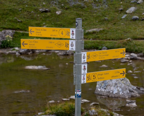
10/07/2025: PATH 7A & 10 CLOSED – Trail 7A from Staffal to the end, and Trail 10 from Gressoney-La-Trinité to the junction with Trail 10B are closed due to ongoing work until a date to be determined.
Don’t know how to choose a hike?
looking for a mountain cabin?
And if you don’t necessarily want to walk…
Gressoney
Gressoney is the name of a unique territorial and cultural entity,
In reality divided into two neighboring municipalities:
Gressoney-Saint-Jean (1385 meters) and Gressoney-La-Trinité (1635 meters).
The two municipalities are located at the apex of the Lys Valley,
one of the longest in the Aosta Valley:
owes its name to the Lys stream that runs through its entire length.
The valley ends at the sight of the southern slope of Monte Rosa,
the largest mountain range in the Alps,
the second highest after Mont Blanc.
Gressoney is a German language island belonging to the Walser community.
The population speaks an Alemannic dialect, Titsch (from Greschòneytitsch)
A tourist center since the 19th century, it attracts mountain enthusiasts from all over the world every year.
This website is dedicated to the Gressoney hiking trails
With the patronage of:
Municipality of Gressoney-Saint-Jean

Municipality of Gressoney-La-Trinité
Tourist office of
Gressoney-Saint-Jean
Villa Deslex
+39 0125 355185
gressoney@turismo.vda.it
Tourist office of
Gressoney-La-Trinité
Piazza Tache
+39 0125 366143
gressoney@turismo.vda.it
Alpine Club of Gressoney
Fraz. Tache 14/d c/o Bazar Thedy
+39 331 7893125
caigressoney@gmail.com
gressoney@pec.cai.it
Aosta Valley and Lys Valley
Valle d’Aosta is an autonomous region in northwestern Italy; it is the smallest (3,263 km2) in the country and includes the highest peaks: Mont Blanc (4807 m), Monte Rosa (4634 m), Matterhorn (4478), and Gran Paradiso (4061 m).
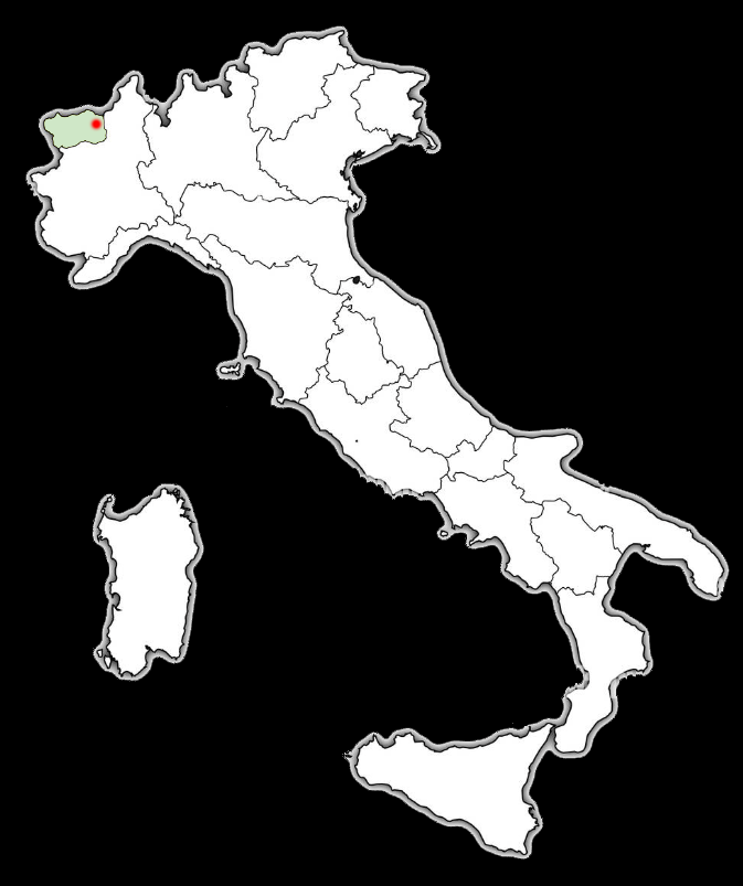
Aosta Valley in Italy
Gressoney-Saint-Jean and Gressoney-La-Trinité are located at the end of the Lys Valley (in red on the map), the first valley on the right when arriving by car from other regions of Italy.
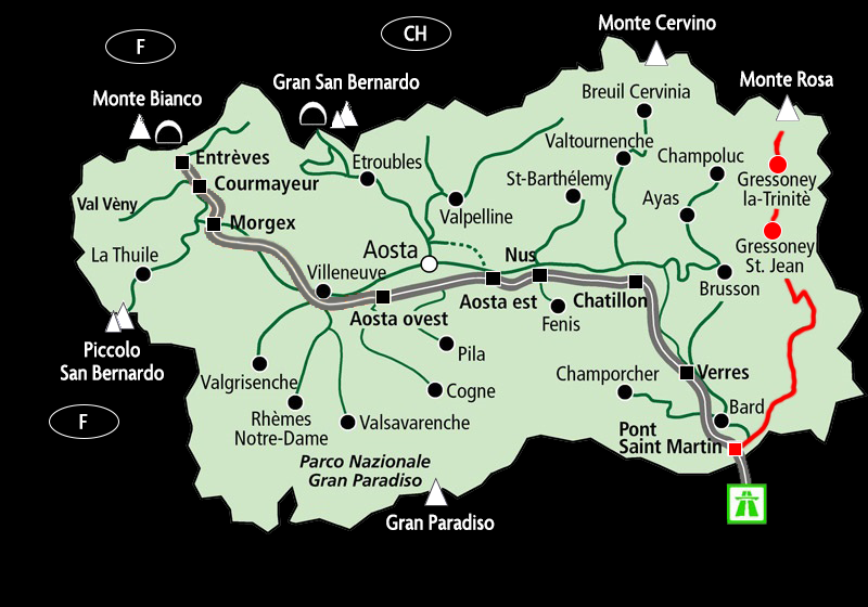
The Lys Valley in the Aosta Valley
Gressoney
Gressoney is the name of a unique cultural and territorial entity in the Italian Alps, actually divided into two neighboring municipalities:
Gressoney-Saint-Jean (1385 meters) and Gressoney-La-Trinité (1635 meters).
The two municipalities are located at the apex of the Lys Valley, one of the longest valleys in the Aosta Valley:
owes its name to the Lys stream that runs through its entire length.
The valley ends at the sight of the southern slope of Monte Rosa, the largest mountain massif in the Alps,
the second highest after Mont Blanc.
Gressoney is a German language island belonging to the Walser community.
The population speaks an Alemannic dialect, Titsch (from Greschòneytitsch)
A tourist center since the 19th century, it attracts mountain enthusiasts from all over the world every year.
This website is dedicated to the Gressoney hiking trails
Aosta Valley and Lys Valley
Valle d’Aosta is an autonomous region in northwestern Italy; it is the smallest (3,263 km2) in the country and includes the highest peaks: Mont Blanc (4807 m), Monte Rosa (4634 m), Matterhorn (4478), and Gran Paradiso (4061 m).
Aosta Valley in Italy
Gressoney-Saint-Jean and Gressoney-La-Trinité are located at the end of the Lys Valley (in red on the map), the first valley on the right when arriving by car from other regions of Italy.
The Lys Valley in the Aosta Valley
With the patronage of:
Municipality of Gressoney-Saint-Jean
Municipality of Gressoney-La-Trinité
Tourist office of
Gressoney-Saint-Jean
Villa Deslex
+39 0125 355185
gressoney@turismo.vda.it
Tourist office of
Gressoney-La-Trinité
Piazza Tache
+39 0125 366143
gressoney@turismo.vda.it
Alpine Club of Gressoney
Fraz. Tache 14/d c/o Bazar Thedy
+39 331 7893125
caigressoney@gmail.com
gressoney@pec.cai.it
Privacy Policy